No archaeology has substantiated the medieval tradition of London (AKA “New Troy”) being founded by Brutus in 1108 BC, or its later incarnation “Caer Lud” (apparently fortified by King Lud when Caesar’s star was in the ascendant). Put bluntly, no substantial Iron Age oppidum preceded the Roman city of Londinium.
Whatever the meaning of the obscure Celtic word “Londinio” it almost certainly referred to a natural feature of the landscape rather than a settlement. For the Celts the Thames marked a boundary. It articulated the no-man’s land between the Catuvellauni and Trinovantes to the north, and the Atrebates and Cantii to the south.
To the Romans, however, the river looked more like a potential highway. At low tide it dropped just over a metre below sea level and it can’t have risen more than a metre above (as this was the level of the lowest surfaces of the first Roman roads). For comparison, present-day high tides often surge above 4.5m with a total tidal range of 7.7m.
The Thames had a shapeshifting character though. At high tide, it could stretch itself almost 1000m-wide while at low tide it was only 300m across its narrowest point, which was where the largest island projected into the deep water channel. It was there that the lowest crossing could be made by a fixed bridge. To summarise, it was not the favoured high ground on the north bank which determined Londinium’s location but the real constraints on the southern shore: Southwark’s (island) topography.

Nevertheless, the town had its core on the north bank terrace which rose to a secure twelve metres above sea level and was sculpted by three main valleys. The first formed by the River Fleet (on the line of the present-day road leading to Blackfriars Bridge), the second moulded by the Walbrook stream, and the third rose above Lorteburn stream (running southwards from Fenchurch Street station). These waterways debouched into the Thames close to what is now Cannon Street station.
These valleys framed the two hills upon which Londinium was built: Ludgate Hill (crowned today by St Paul’s) and Cornhill (which legend and medieval tradition claimed as the site of the city’s original cathedral, St Peter’s upon Cornhill). Thus the position of Londinium was determined by an island off Southwark (where the Thames could be crossed) and the easy defensible position defined by river valleys to its east and west.
The town swiftly evolved into the chief node of the Roman communications network in Britain. Initially served by a ferry crossing, its roads led to the channel-ports of the south, the capital at Colchester (Camulodunum) in the east, and the military frontiers to the north and west. Food, goods and equipment destined for the army could be brought there by road from Richborough or upriver by boat.
This “first” London incorporated a central core of 37 acres. An underwhelming settlement compared to Colchester which stood at 93 acres. But it still bustled with industry: at Gateway House (near Watling Court), for instance, there’s evidence of glass-blowing debris, while at Cheapside gem-cutting was clearly practised. Elsewhere, the city proper was surrounded by potteries that sought to take advantage of the London clay exposed on the shoreline at low tide. And despite lacking official status as a municipium (it lacked public buildings altogether) Londinium was clearly important enough to merit sacking by Boudica’s army. Indeed, within a decade of its foundation the town was destroyed (AD 61).

Perhaps the most significant development for the second town was its forum and basilica near the current day Guildhall. It comprised four wings arranged around a central courtyard and its basilica lay to the north with a nave separated from the side aisles by columns or piers, and a tribunal to the east. To the structure’s east was a (20 X 10m) temple and elsewhere two bath-houses were built, one at Cheapside and another at Huggin Hill (EC4), the latter terraced into the steep hillside next to the Thames. The paint had barely dried on the old forum before it underwent an upgrade that took thirty years to complete. The new structure was 170 X 170m – nearly four times the size of its predecessor (as exposed on the Leadenhall Court site in 1986). A twelve-acre fort was also built at Cripplegate (its northern and western edges remain visible, along with Saxon fortifications as part of the Barbican and Museum of London complex) to the north and west of the main centre but conveniently next to the amphitheatre at Guildhall Yard (by the church of St Lawrence Jewry where Thomas More later preached). The oval covered an area roughly 100m wide and one of its drains rather ominously contained the remains of five humans and a bull’s skull. Elsewhere, obstacles such as the tributaries of the Walbrook stream (which reached their confluence just north of the Bank of England) were overcome by infilling. Each channel was covered with clay and gravel and the streams canalised between timber revetments. Meanwhile, the main harbour of the city formed around the end of Fish Street Hill and Pudding Lane where the quay, bridge pier, custom house, storage depots etc. all stood. The remains of storage jars show that 80 percent of vessels came from Spain and southern France with roughly half being used to carry olive oil, 10 percent garum, 6 percent defrutum, and 3 percent olives. The majority of the remainder carried wine. Some of the jars had rough and ready advertisements. On an amphora from Southwark (near a temple of Isis no less) for example was scribbled “Lucius Tettius Africanus’ finest fish sauce from Antipolis.” While others boasted Greek names (a Koan amphora bore the name Theourou). Tablets conveyed grimmer news from a certain Rufus:
"Rufus calllisuni salutem epillico et omibus contubernalibus certiores vos essecredo ne recte valere si vos indicem fecistis rogo mittie omniadiligenter cura agas ut illam puellam ad nummum redigas …”
(Rufus, son of Callisunus, greeting to Epillicus and all his fellows. I believe you know I am very well. If you have made the list, please send. Do look after everything carefully – indeed, see that you turn that slave-girl into cash).

A clear reference to the slave trade. While a lead plaque records that an individual sought to curse “Tertia Maria and her life and mind and memory and live and lungs mixed up together… Thus may she be unable to speak…”
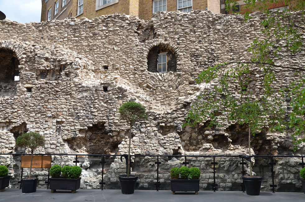
One of the more costly works (though not the most famous thanks to Bloomberg’s purchase of the early third-century Mithreaum at 12 Walbrook Street) was the construction of the two-mile landward wall between AD 190-220. Almost three-metres thick at its base and over six-metres high, it may have been built for protection or status-enhancement (or both) and is still visible at St Alphage, Cooper’s Row and Tower Hill. Constructed from ragstone rubble separated by four tile courses with a sandstone plinth at the base, its precise alignment beyond Ludgate remains uncertain but it probably ran south to the Thames. The London waterfront was later enclosed behind a defensive wall (in the late third century).
Apart from the two that accessed Cripplegate fort there were five main gates to Londinium. They punctuated the wall at Aldgate, Bishopsgate, Aldersgate, Newgate and Ludgate. Indeed, fragments of a monumental arch were found reused in the riverside wall near Blackfriars in 1976.

After London’s long, slow demise in the fourth and fifth centuries (the treatment of its quays and kilns, neither maintained or repaired, seems symptomatic) the Anglo-Saxons preferred to start from scratch. Indeed, their settlement even assimilated parts of an old Roman cemetery at St Martin-in-the-Fields (as a side-note it’s interesting to highlight that what church Restitutus, the bishop London sent to the Council of Arles in AD 314, belonged to remains uncertain). From a Christian standpoint, St Mellitus’ mission to London was abortive with the East Saxons reverting to paganism on the death of Sæberht (616), forcing the prelate to flee to to Gaul and Canterbury. Not until Cedd (elder brother to St Chad) was consecrated in 654 was there a nominal Christian presence. And even then it was really Erkenwald – selected by the formidable Byzantine Theodore of Tarsus – who kick-started evangelism in the capital (the Lincoln-lad is still the patron saint of London today). All Hallow’s [at the Tower] provides a remarkable remnant of this period having been founded in 675 by the Saxon abbey at Barking (it still contains a seventh century Saxon arch made from reused Roman tiles, as well as a second-century mosaic). The Germanic settlement of Lundenwic (confirmed by a seventh-century cup at St Martin-in-the-Fields, the late seventh-century Garrick Street ring, and the beautiful eighth-century Fetter Lane sword pommel) was probably accelerated by Wulfhere of Mercia 658–75 (when references to “portum Lundoniae” and “supra vicum Lundoniae” rocketed). It lay outside the old Roman walls – to the west of the city – in the Aldwych (between Drury Lane and the Thames). It’s worth remembering that the distance between these two Londons was not particularly small. It is still a two-mile walk from the Savoy Hotel of Lundenwic to the St Paul’s cathedral of Londinium with Fleet Street forming the main artery then as now.
Comments